NORTHWEST
TERRITORY
|
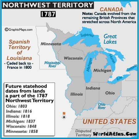
In the 18th century, Great Britain and the French Crown disputed for control of this region. The French had claimed it in the 17th century as part of the New France Province of Quebec; the competition between the nations was one cause of the French and Indian War (known as the Seven Years' War in Europe). After Britain gained control following its defeat of France in 1763, its attempts to reserve the territory for use by Native Americans under the Royal Proclamation of 1763 roused resentment among British colonists, who were already seeking to settle west of the Appalachian Mountains. The region was assigned to the United States in the Treaty of Paris of 1783, but sporadic westward emigrant settlements had already resumed late in the war after the Iroquois Confederation's power was broken and the tribes scattered by the 1779 Sullivan Expedition. It boomed soon after the Revolution ended as the westward traffic spurred expansion of a gateway trading post into the town of Brownsville, Pennsylvania as a key outfitting center west of the mountains. Other wagon roads, such as the Kittanning Path surmounting the gaps of the Allegheny in central Pennsylvania, or trails along the Mohawk River in New York let a steady stream of settlers reach the near west and the lands bordering the Mississippi. This activity stimulated the development of the eastern parts of the eventual National Road by private investors. The Cumberland–Brownsville toll road linked the water routes of the Potomac River with the Monongahela River of the Ohio/Mississippi riverine systems in the days when water travel was the only good alternative to walking and riding. Most of the territory and its successors was settled by emigrants passing through the Cumberland Narrows, or along the Mohawk Valley in New York State. The Congress of the Confederation enacted the Northwest Ordinance in 1787 to provide for the administration of the territories and set rules for admission of jurisdictions as states. On August 7, 1789, the new U.S. Congress affirmed the Ordinance with slight modifications under the Constitution. The territory included all the land of the United States west of Pennsylvania and northwest of the Ohio River. It covered all of the modern states of Ohio, Indiana, Illinois, Michigan, and Wisconsin, as well as the northeastern part of Minnesota. The post-American Revolutionary War Territory Northwest of the River Ohio, more commonly known as the Northwest Territory encompassing most of the pre-war territory of the Ohio Country, was an organized incorporated territory of the United States spanning most or large parts of six eventual U.S. States. It existed legally from July 13, 1787, until March 1, 1803, when the southeastern portion of the territory was admitted to the Union as the state of Ohio, and the remainder was reorganized by additional legislative actions. |
|
The
Territory of the United States Northwest of the River Ohio Ordinance of 1787
makes no mention of a seal. [1] The Laws of the Territory of the United
States Northwest of the River Ohio make no provision for a seal for the
territory either. According
to one letter from the Department of State, “‘The earliest mention of use of
the seal is in [Governor Arthur] St. Clair’s proclamation of July 26, 1788’”
It was: “A
landscape with a river and mountains in the distance, a sun in the sky, on
the river two boats and on the foreground a coiled snake, an apple tree and a
felled forest tree into logs. In base the motto ‘MELIOREM LAPSA LOCAVIT!’(He has planted a better than the
fallen.). All within the legend THE SEAL OF THE TERRITORY OF THE U.S.N.W. OF
THE RIVER OHIO.” [2] |
|
Seal of Nortwest
Territory 1788 [3] The seal
was more or less legitimized by an Act of Congress, approved May 8, 1792,
directing the U.S. Secretary of State to “provide proper seals for the
several and respective public offices in the said Territories [northwest and
south of the river Ohio].” [4] |

© Hubert de Vries 2017-04-24